Council approves Spine Road Development Corridor Framework
09 December 2025
On Thursday, 4 December 2025, Council approved the local spatial development framework (LSDF) for the Spine Road Development Corridor in Khayelitsha. Over time, the corridor has experienced increasing pressure from both formal and informal development. The LSDF framework aims to identify and guide opportunities for enhancements that support residents, road users, small-scale business owners, micro-developers and private landowners.
‘There is an urgent need for a spatial vision to guide sustainable development along this corridor in a manner that supports economic growth, and improves mobility, environmental sustainability and resilience to the impacts of climate change.
‘Spine Road is extremely congested. There is pressure from a multitude of land uses and activities in the road reserve – these range from car washes to salons, restaurants, local mechanics and spaza shops. There are informal encroachments with structures built over service servitudes, in some cases obstructing access to essential infrastructure, such as water and sewer mains,’ said the City’s Deputy Mayor and Mayoral Committee Member for Spatial Planning and Environment, Alderman Eddie Andrews.
Spine Road is a major urban axis extending approximately 12 kilometres through the heart of Khayelitsha, beginning at the N2/Spine Road interchange in the East and terminating at Mew Way/Spine Road intersection in the West. The corridor passes through and connects a range of distinct, but interrelated neighbourhoods, including Eyethu, Ekuphumleni, Sabata Dalindyebo Square, Mandela Park, Ilitha Park, and Khaya. It links formal and informal residential areas, civic amenities, economic clusters, and public transport interchanges.
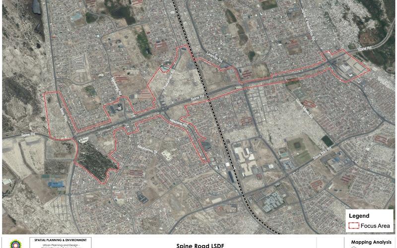
Spine Road functions as both a mobility spine and a development backbone for the region.
‘We want to see medium- to high-density housing and mixed-use developments at appropriate locations. Development and investment should support business growth, create job opportunities, improve public transport, promote non-motorised transport, and ease traffic flow. Most importantly, whatever happens along this corridor must improve living conditions through green spaces and eco-friendly infrastructure,’ said Alderman Andrews.
The Spine Road Development Corridor LSDF also aims to introduce four spatial precincts to guide and manage development along the corridor:
- Mew Way Node: Civic Gateway and Southern Anchor
- Makabeni Hub: Central Mixed-Use and Trading District
- Khaya Industrial: Strategic Employment Precinct in Transition
- Vuyani Market: Informal Economy Integration and Public Realm Upgrade
The formal public participation period ran from 21 February to 22 April 2025, with multiple forms of notification issued to raise awareness. Two public workshops were held at the Khayelitsha CBD Hall and Subcouncil 10 Office on 5 March and 14 March 2025.
More than 100 comments were received through written submissions, workshop discussions and internal departmental feedback.
Input from traders, community members and design stakeholders highlighted the need for a clearer approach to permit systems, infrastructure support and designated trading areas. Concerns were raised around pedestrian safety, particularly near schools and busy intersections, as well as the need for accessible public ablutions and improved crime prevention. The LSDF now includes enhanced public-realm design proposals, especially in Makabeni and Mew Way, with a focus on lighting, signage and safer pedestrian infrastructure.
Other comments also addressed mobility challenges; including the need for service roads, slip lanes and better pedestrian and cycling routes. Public and internal feedback emphasised the importance of environmental sustainability, green infrastructure and access to quality open space.
Implementation will be phased and is subject to budget allocations, and ongoing stakeholder coordination.
Implementation timeframes are structured as follows:
Short term (1–3 years):
- Pedestrian infrastructure upgrades
- Informal trading zone development
- Public-realm enhancements
Medium term (3–5 years):
- Makabeni Precinct regularisation and business support
- Lookout Hill redevelopment within the broader Makebeni area
- Access and mobility corridor upgrades
- Informal settlement upgrading/relocation
- Economic activation and skills centres
Long term (5–10 years):
- Integrated trading and market hubs
- Community amenities and recreation nodes
Implementation is subject to several constraints, including land recovery, budget allocations and ongoing stakeholder coordination.
The full Spine Road Development Corridor LSDF recommendation for approval document is available on this page (Item 28 - C04/12/25 on the list).
End
Published by:
City of Cape Town, Media Office